The dynamic monitoring of land law enforcement is one of the main duties of the Land and Resources Law Enforcement Institute. Due to various factors, there are certain difficulties in the inspection work. In the case of the original vehicle personnel and manual inspection personnel, there are illegal land use discoveries. The disadvantages are low rate, unsuccessful discovery, time-consuming and labor-intensive. There will be cases such as "not patrolling, not seeing all, arguing, and discovering late".
Compared with the traditional data acquisition and update methods, the UAV aerial photography system has the advantages of low cost, high efficiency and fast access to high-resolution and large-scale images. It can be used as an effective supplement to traditional data collection and update methods to meet information. The need for technological development. Then, when conducting the land surveillance inspection of the drone, the following points should be noted, so that we can obtain the relevant two-dimensional front view more efficiently and safely, so that it can be manually identified later.
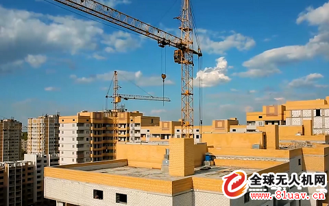
Work height selection
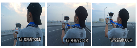
When carrying out daily routine inspections of drones, it is often encountered in buildings with different heights in a certain area. If the height of the obstacles on the front is different due to the height of the automatic patrol at the same height, the flight of the drone may be hindered. Even a crash accident occurs. Therefore, when starting the operation, it is necessary to select the working height above the highest building in the line of sight. After the drone reaches the specified flying height, the operation can be started to prevent the encounter. Impact. For some higher building areas (such as office buildings), you can choose to bypass or perform a mission at a relatively high takeoff point.
Overlap rate parameter setting
The overlap rate refers to the overlap between the two photos. Usually, according to the normal late positive photography, the higher the overlap rate, the better the synthesis work, but the large amount of photo data will also greatly increase the processing time of the computer, and reduce the efficiency of the drone flight, so When performing surveying and mapping, if you need to carry out more complicated post-work tasks, such as point cloud map and stereo map production, you can set the "airborne overlap rate" to 80%. For orthophoto results, the general heading and side overlap The rate can reach 60%.
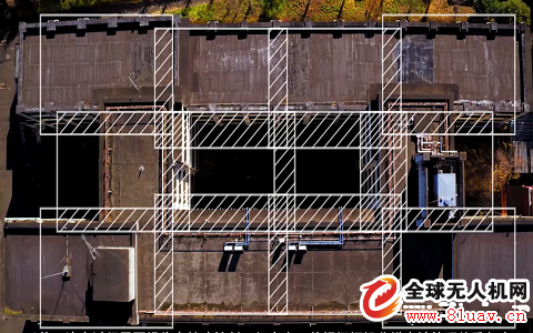
↑Image overlap rate
Choice of takeoff point
When using the ground station software to control the drone for autonomous flight, the drone performs the mission by reading the mission information uploaded by the ground station. During the mission of the drone, after the drone exceeds the line of sight, the naked eye cannot capture the position of the drone. It is possible that due to interference from uncontrollable factors in the air (such as electromagnetic, wind and obstacles), it is necessary for the operator to perform manual operation intervention. The operator should pay attention to the drone at any time and control the drone at any time. Therefore, you need to pay attention to the following three points:
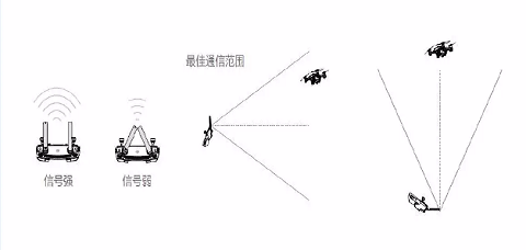
â–ˆ Make sure that the strongest end of the remote control antenna (flat side of the flat panel antenna) points to the drone. When the distance is farther, lift the remote control appropriately to ensure the signal connection is normal.
↑Aircraft height and remote control
â–ˆ Be sure to fly in low-interference environments while away from high-altitude flights over long distances in signal-intensive areas such as downtown areas, launch stations, and high-voltage cables;
â– Minimize barriers between the controller and the drone. The obstruction will block the communication between the drone and the remote control (ground station), so that the device such as the picture/digital transmission cannot be returned in real time, and the operator cannot see the drone, which makes the aircraft flight have certain security risks.
Compared with the traditional data acquisition and update methods, the UAV aerial photography system has the advantages of low cost, high efficiency and fast access to high-resolution and large-scale images. It can be used as an effective supplement to traditional data collection and update methods to meet information. The need for technological development. Then, when conducting the land surveillance inspection of the drone, the following points should be noted, so that we can obtain the relevant two-dimensional front view more efficiently and safely, so that it can be manually identified later.
Work height selection
When carrying out daily routine inspections of drones, it is often encountered in buildings with different heights in a certain area. If the height of the obstacles on the front is different due to the height of the automatic patrol at the same height, the flight of the drone may be hindered. Even a crash accident occurs. Therefore, when starting the operation, it is necessary to select the working height above the highest building in the line of sight. After the drone reaches the specified flying height, the operation can be started to prevent the encounter. Impact. For some higher building areas (such as office buildings), you can choose to bypass or perform a mission at a relatively high takeoff point.
Overlap rate parameter setting
The overlap rate refers to the overlap between the two photos. Usually, according to the normal late positive photography, the higher the overlap rate, the better the synthesis work, but the large amount of photo data will also greatly increase the processing time of the computer, and reduce the efficiency of the drone flight, so When performing surveying and mapping, if you need to carry out more complicated post-work tasks, such as point cloud map and stereo map production, you can set the "airborne overlap rate" to 80%. For orthophoto results, the general heading and side overlap The rate can reach 60%.
↑Image overlap rate
Choice of takeoff point
When using the ground station software to control the drone for autonomous flight, the drone performs the mission by reading the mission information uploaded by the ground station. During the mission of the drone, after the drone exceeds the line of sight, the naked eye cannot capture the position of the drone. It is possible that due to interference from uncontrollable factors in the air (such as electromagnetic, wind and obstacles), it is necessary for the operator to perform manual operation intervention. The operator should pay attention to the drone at any time and control the drone at any time. Therefore, you need to pay attention to the following three points:
â–ˆ Make sure that the strongest end of the remote control antenna (flat side of the flat panel antenna) points to the drone. When the distance is farther, lift the remote control appropriately to ensure the signal connection is normal.
↑Aircraft height and remote control
â–ˆ Be sure to fly in low-interference environments while away from high-altitude flights over long distances in signal-intensive areas such as downtown areas, launch stations, and high-voltage cables;
â– Minimize barriers between the controller and the drone. The obstruction will block the communication between the drone and the remote control (ground station), so that the device such as the picture/digital transmission cannot be returned in real time, and the operator cannot see the drone, which makes the aircraft flight have certain security risks.
↑ remote control signal transmission
This issue of our drone inspection technology lecture hall is here, welcome interested friends to leave a message and exchange in the message area below, we will not see the next inspection class.Shenzhen ChengRong Technology Co.,Ltd. , https://www.laptopstandsuppliers.com